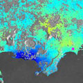
Scientists are making advances in the use of satellite radar data - such as those from the Sentinel-1 mission - to monitor Earth's changing surface.
Scientists are making advances in the use of satellite radar data - such as those from the Sentinel-1 mission - to monitor Earth's changing surface.
Italy's Phlegraean Fields - or Campi Flegrei - is a large, active volcanic area near the city of Naples near Mount Vesuvius. Since the 1970s, the ground has been rising owing to the volcanic nature of this area.
"In 2012, deformation rates up to 3 cm a month prompted the Italian Civil Protection Department to move from the base (green) alert level of the Campi Flegrei Emergency Plan to the attention (yellow) level," said Sven Borgstrom from Italy's National Institute for Geophysics and Volcanology.
"The uplift continues today: radar imagery from the Sentinel-1A satellite captured over the area between October 2014 and March 2015 show that the ground is rising by about 0.5 cm per month."
This is just one of the many findings being presented this week at the Fringe Workshop on advances in the science and applications of 'SAR interferometry' held at ESRIN, ESA's centre for Earth observation, in Frascati, Italy.
