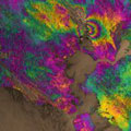
Sentinel-1A has added yet another string to its bow. Radar images from this fledgling satellite have been used to map the rupture caused by the biggest earthquake that has shaken northern California in 25 years.
Sentinel-1A has added yet another string to its bow. Radar images from this fledgling satellite have been used to map the rupture caused by the biggest earthquake that has shaken northern California in 25 years.
Scientists collaborating through the UK Natural Environment Research Council's Centre for the Observation and Modelling of Earthquakes, Volcanoes and Tectonics (COMET), used Sentinel-1A's special capabilities to analyse the quake.
'Synthetic aperture radar interferometry' is a technique where two or more satellite radar images of the same area are combined to detect large-scale surface changes. Small changes on the ground modify the reflected radar signal and lead to rainbow-coloured fringes in the 'interferogram'.
Yngvar Larsen from Norway's Northern Research Institute and Petar Marinkovic from PPO.labs in the Netherlands processed this new interferogram from two images: one that Sentinel-1A acquired on 7 August, the day the satellite reached its operational orbit, and another captured on 31 August.
