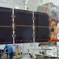
Imaging Earth's land with unprecedented speed and resolution has come another step closer as the next Sentinel satellite has been given its solar wing and started a strenuous six-month test campaign to make sure that it is fit for launch next April.
Imaging Earth's land with unprecedented speed and resolution has come another step closer as the next Sentinel satellite has been given its solar wing and started a strenuous six-month test campaign to make sure that it is fit for launch next April.
Sentinel-2A is the next of ESA's suite of satellites to be launched for Europe's Copernicus programme - the largest Earth monitoring programme in the world.
This new satellite carries a multispectral imager to deliver an unprecedented combination of spatial, spectral and temporal resolution, along with systematic coverage of land and coastal areas.
With a growing global population in mind, the mission will provide key information to optimise crop yield, thereby helping to improve food security. Data will also be used to measure leaf area index, leaf chlorophyll and leaf water content to monitor plant growth. This will support effective crop management during the growing season.
